
A common problem that new Geocachers face is GPSr accuracy or perceived accuracy. Today’s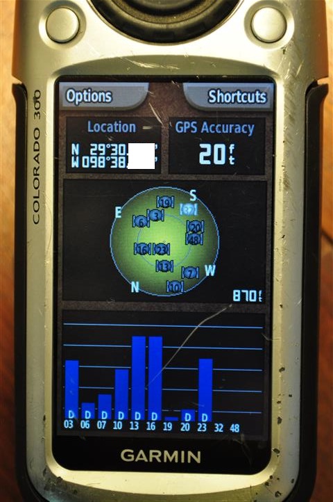 electronic devices are amazing when it comes down to pinpointing location but there are a few things to take into account when hiding or finding caches. So why are my coordinates off?
Whenever talking about the Global Positioning System (GPS) the language can get quite techy so we’ll try to keep the geekness to a low level. If you want to skip the science lesson scroll down to Tips on finding a cache.
Jump Ahead To
Geeky Stuff
The GPS infrastructure takes great steps to provide accurate location and time information in all weather conditions with line-of-sight reception to 4 or more GPS satellites (Triangulation requires 3, elevation from the 4th).
Time and position messages are sent from all of the acquired satellites and the receiver computes its position according to a navigation equation:
![]()
I know what you are thinking. “I was told there would be no math!” Luckily your GPSr or smartphone does all the math for you.
For a minimum performance baseline, currently there are 24 slots to the GPS constellation with at least 1 operational satellite in each slot. At the beginning of 2013 there were 32 satellites in the GPS constellation. There are 4 key aspects to the Standard Positioning Service (SPS) Signal in 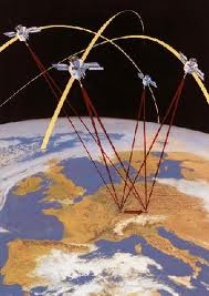 Space (SIS) accuracy:
- User Range Error (data set accuracy)
- User Range Rate Error (time derived part of the data set)
- User Range Acceleration Error (second time derived part of the data set)
- UTC Offset Error (time of day)
So, what does all this mean? VERY simply, it means that there are a number of factors that can affect any one of the variables in the equation. There might be cloud or tree cover, moisture in the atmosphere, number of satellites in view, multi-path conditions (signal bounce), quality of the GPS receiver, the satellite may have marginally drifted from its orbit and the math isn’t accounting for it, ferrous metals in the surrounding ground affecting the compass in the receiver, the list could go on….. It all boils down to the timing between the acquired satellites and the receiver. If there are fewer factors involved that affect the original signal, the accuracy will be greater.
Tips on finding a cache:
- Ensure a clear view of the sky.
- Just after powering up your device, give it time to stabilize before trying to use it to navigate. (Its acquiring more satellites)
- Don’t hold the GPSr or smartphone near anything.
- Don’t put the receiver on the ground
- If you still can’t find the cache, pick a bearing perpendicular to the one that led you to the cache to begin with and back away from Ground Zero by about 40 feet. Move towards where your GPSr leads you and continue searching.
- A third attempt may be used to sort of triangulate the cache’s hiding spot using the method described in #5.
- If caching with a friend, take the average of both devices (Cacher A: 17 feet from here Cacher B: 25 feet from here-Try looking at 21 feet)
- Look over your head. You might have accurate lat/long data but your are not taking the elevation into account. It might be on the bridge above you, hanging in a tree, or in a fake storm drain at your feet.
- Look up from the GPSr and ask yourself, “Where would I hide this?” Look there.
- Purchase a Trimble S7 Robotic Total Station Kit. Accuracy is about 1mm. Cost is around $28,000 (The hider would have had to use a similar device for this to make difference).
How to ensure that your coordinates are as accurate as possible when hiding a cache:
- Get as close to your hiding spot with a clear view of the sky
- Wait for your device to acquire more satellites. The more the merrier.
- Don’t put your GPSr next to anything while marking the coordinates including the ground.
- Navigate to the satellites view of your GPSr and position the receiver to obtain the best signal from all acquired satellites
- Take multiple samples (more than 5) of your coordinates over a period of time (90 minutes for best results, but you probably won’t have 7.5 hours to spare so try to 5 samples in 15 minutes) and average them. Your GPSr might do this for you.
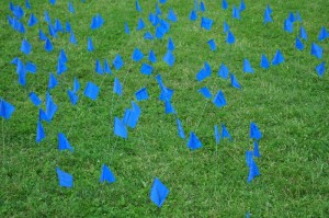
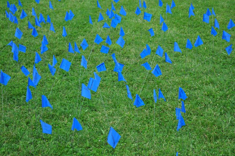
Each flag represents where Geocacher’s GPS receivers brought them using the same coordinates
Include the brand/model number and accuracy of your GPSr or smartphone, at the time that you captured the coordinates, in the cache description. Most like models behave similarly in the same conditions.
- Remember if your GPSr reports its accuracy at 20 feet and the hider’s device’s accuracy was 20 feet when they hid it, then your Ground Zero can be up to 40 feet off from the posted coordinates. This is common and many Geocachers report how far off their device was when they log the cache online. (15-25 feet is very common)
- If you are interested in a in-depth study, there are many sites online dedicated to providing this information.